
Mapa topográfico Φιλότι
Mapa interactivo
Haga clic en el mapa para ver la altitud.
Acerca de este mapa
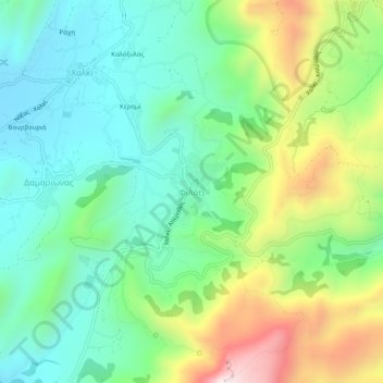
Nombre: Mapa topográfico Φιλότι, altitud, relieve.
Altitud media: 482 m
Altitud mínima: 251 m
Altitud máxima: 973 m
Filoti (in Greek: Φιλώτι or Φιλότι; officially: Φιλότιον) is a semi-mountainous village of central Naxos, Greece, with a population of 1,477 residents (census 2011), located at the foot of Mt. Zas (1,004 m), at an altitude of 400 meters, about 18.2 kilometres (11.3 mi) from the city of Naxos. It is located on the slopes of two hills and consists of three settlements, Rachidi, Klefaros and Lioiri. Its stand out is the Orthodox church of Panagia Filotitissa that is dedicated to the Assumption of the Virgin, a basilica built in 1718 in the place of an old Byzantine church. The economy of the village is mainly based on livestock products, secondarily in agriculture and tourism. It has a Primary School (since 1838), a Professional High School, a Multipurpose Regional Doctor, a Citizen Service Center (KEP), a Post office, a dentist and a pharmacy.
Otros mapas topográficos
Haga clic en un mapa para ver su topografía, su altitud y su relieve.
Naxos
Greece > Aegean > Naxos Regional Unit
Naxos, Municipality of Naxos and the Lesser Cyclades, Naxos Regional Unit, South Aegean, Aegean, 843 00, Greece
Altitud media: 33 m
Naxos
Greece > Aegean > Naxos Regional Unit
Naxos, Naxos Regional Unit, South Aegean, Aegean, Greece
Altitud media: 112 m