Geolocalizar

Mapa topográfico Champia

Mapa interactivo

Haga clic en el mapa para ver la altitud.

Acerca de este mapa

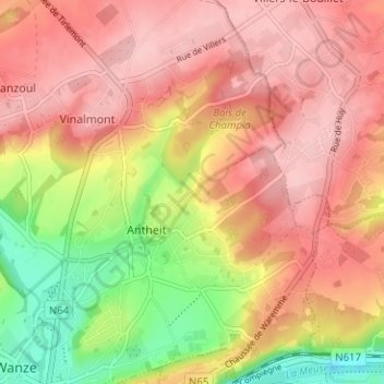
Nombre: Mapa topográfico Champia, altitud, relieve.

Lugar: Champia, Wanze, Huy, Liège, Wallonie, 4520, Belgique (50.53507 5.22338 50.57507 5.26338)

Altitud media: 149 m

Altitud mínima: 55 m

Altitud máxima: 206 m

Otros mapas topográficos

Haga clic en un mapa para ver su topografía, su altitud y su relieve.

Oha

Belgique > Liège > Huy > Wanze > Bas-Oha

Oha, Bas-Oha, Wanze, Huy, Liège, Wallonie, 4520, Belgique

Altitud media: 117 m

Le Taillis

Belgique > Liège > Huy > Wanze > Moha

Le Taillis, Moha, Wanze, Huy, Liège, Wallonie, 4520, Belgique

Altitud media: 138 m

Le Tilleul

Belgique > Liège > Huy > Wanze > Le Tilleul

Le Tilleul, Wanze, Huy, Liège, Wallonie, 4520, Belgique

Altitud media: 119 m

Wanzoul

Belgique > Liège > Huy > Wanze

Wanzoul, Wanze, Huy, Liège, Wallonie, 4520, Belgique

Altitud media: 154 m

Antheit

Belgique > Liège > Huy > Wanze

Antheit, Wanze, Huy, Liège, Wallonie, 4520, Belgique

Altitud media: 137 m

Vinalmont

Belgique > Liège > Huy > Wanze

Vinalmont, Wanze, Huy, Liège, Wallonie, 4520, Belgique

Altitud media: 156 m