
Haz una donación
Mapa topográfico Muztagh Ata
Haga clic en el mapa para ver la altitud.
Haz una donación
Muztagh Ata
Muztagh Ata (meaning 'Ice Mountain Father' in English), formerly known as Mount Tagharma and Wi-tagh, is the second highest of the mountains which form the northern edge of the Tibetan Plateau, with an elevation of 7,546 m (24,757 ft). It is sometimes regarded as being part of the Kunlun Mountains, although physically it is more closely connected to the Pamirs. It is one of the relatively easier 7,000 m peaks in the world to climb, due to its gentle western slope and the comparatively drier weather of Xinjiang, though a thorough acclimatization period and a very strong physical condition are crucial for success.
Haz una donación
Acerca de este mapa
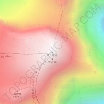
Nombre: Mapa topográfico Muztagh Ata, altitud, relieve.
Altitud media: 6.786 m
Altitud mínima: 5.449 m
Altitud máxima: 7.520 m
Haz una donación
Otros mapas topográficos
Haga clic en un mapa para ver su topografía, su altitud y su relieve.