
Mapa topográfico Eibar
Mapa interactivo
Haga clic en el mapa para ver la altitud.
Acerca de este mapa
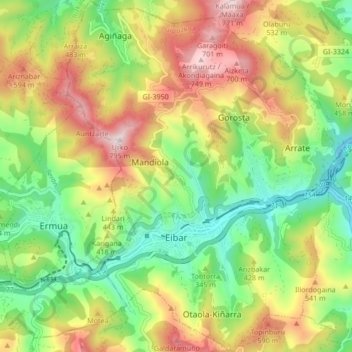
Nombre: Mapa topográfico Eibar, altitud, relieve.
Altitud media: 367 m
Altitud mínima: 74 m
Altitud máxima: 768 m
Eibar lies at an altitude of 121m above sea level, in the west of the province of Gipuzkoa, right next to Biscay. Eibar has an oceanic climate. The town lies in a narrow valley in a mountainous area, the highest mountains are between 700 and 800 metres high. Eibar is traversed by river Ego, which is a tributary of the Deba.
Otros mapas topográficos
Haga clic en un mapa para ver su topografía, su altitud y su relieve.
Karakate
Spain > Autonomous Community of the Basque Country > Debabarrena > Soraluze
Karakate, Soraluze, Debabarrena, Gipuzkoa, Autonomous Community of the Basque Country, 20590, Spain
Altitud media: 366 m
Elgoibar
Spain > Autonomous Community of the Basque Country > Debabarrena > Elgoibar
Elgoibar, Debabarrena, Gipuzkoa, Autonomous Community of the Basque Country, Spain
Altitud media: 321 m