
Gracias por apoyar a este sitio ❤️
Haz una donación
Haz una donación
Mapa topográfico Yucca Valley
Haga clic en el mapa para ver la altitud.
Gracias por apoyar a este sitio ❤️
Haz una donación
Haz una donación
Yucca Valley
Yucca Valley lies in the middle of the Morongo Basin at a base elevation of 3,300 feet. Joshua Tree National Park is adjacent to its southern border.
Gracias por apoyar a este sitio ❤️
Haz una donación
Haz una donación
Acerca de este mapa
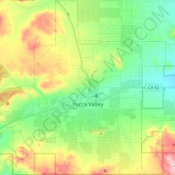
Nombre: Mapa topográfico Yucca Valley, altitud, relieve.
Altitud media: 1.106 m
Altitud mínima: 897 m
Altitud máxima: 1.501 m
Gracias por apoyar a este sitio ❤️
Haz una donación
Haz una donación
Otros mapas topográficos
Haga clic en un mapa para ver su topografía, su altitud y su relieve.