
Mapa topográfico Moss Landing
Mapa interactivo
Haga clic en el mapa para ver la altitud.
Acerca de este mapa
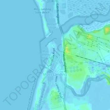
Nombre: Mapa topográfico Moss Landing, altitud, relieve.
Altitud media: 1 m
Altitud mínima: -6 m
Altitud máxima: 18 m
Moss Landing, formerly Moss, is an unincorporated community and census-designated place (CDP) in Monterey County, California, United States. It is located 18 miles (29 km) north-northeast of Monterey, at an elevation of 10 feet (3.048 m). It is on the shore of Monterey Bay, at the mouth of Elkhorn Slough and at the head of the submarine Monterey Canyon.