
Mapa topográfico Skopelos
Mapa interactivo
Haga clic en el mapa para ver la altitud.
Acerca de este mapa
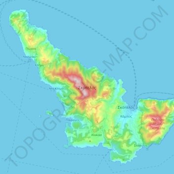
Nombre: Mapa topográfico Skopelos, altitud, relieve.
Altitud media: 59 m
Altitud mínima: -1 m
Altitud máxima: 658 m
The second largest settlement is Glossa village, situated on the northwestern tip of the island, just above Loutraki harbour, with an elevation ranging from 200 to 300 m (656 to 984 ft). It is 25.4 km (15.8 mi) from Skopelos town. It is a tranquil village with traditional houses, with 993 residents.