
Haz una donación
Mapa topográfico Jiujiang
Haga clic en el mapa para ver la altitud.
Haz una donación
Acerca de este mapa
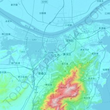
Nombre: Mapa topográfico Jiujiang, altitud, relieve.
Lugar: Jiujiang, Xunyang District, Jiujiang, Jiangxi, China (29.50538 115.78749 29.82538 116.10749)
Altitud media: 118 m
Altitud mínima: 8 m
Altitud máxima: 1.429 m
Haz una donación
Otros mapas topográficos
Haga clic en un mapa para ver su topografía, su altitud y su relieve.
Jingdezhen
Jingdezhen is situated in the north-east of Jiangxi and borders on Anhui; the city center area is located in the north-east of the Poyang Lake Plain. Its area is 5,256 km2 (2,029 sq mi). The highest point is 1,618 m (5,308 ft), with plains on the southern part having an average altitude of 200 m (660 ft).
Altitud media: 167 m
Haz una donación
Xingguo County
The length from east to west is 84 kilometers and the width from north to south is 71.5 kilometers. Xingguo is mostly covered by hills and mountains: mountains over 1000 meters on the east, north and west edges, while hilly areas in the center and south parts, with a small basin around the county seat…
Altitud media: 321 m
Haz una donación
Haz una donación
Haz una donación
Haz una donación
Haz una donación
Jingdezhen
Jingdezhen is situated in the north-east of Jiangxi and borders on Anhui; the city center area is located in the north-east of the Poyang Lake Plain. Its area is 5,256 km2 (2,029 sq mi). The highest point is 1,618 m (5,308 ft), with plains on the southern part having an average altitude of 200 m (660 ft).
Altitud media: 167 m
Haz una donación
Haz una donación
Haz una donación
Haz una donación
Haz una donación
Jinggang Mountains Nature Reserve
China > Jiangxi > Jinggangshan City > Ji'an City
The range lies at the junction of four counties - Ninggang, Yongxing, Suichuan and Lingxian. The mountains cover some 670 km2 (260 sq mi), with an average elevation of 381.5 metres (1,252 ft) above sea level. The highest point is 2,120 m (6,960 ft) above sea level.
Altitud media: 749 m
Haz una donación