
Gracias por apoyar a este sitio ❤️
Haz una donación
Haz una donación
Mapa topográfico Pampady
Haga clic en el mapa para ver la altitud.
Gracias por apoyar a este sitio ❤️
Haz una donación
Haz una donación
Acerca de este mapa
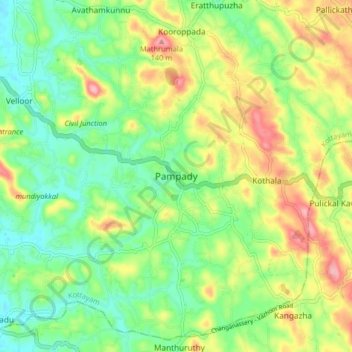
Nombre: Mapa topográfico Pampady, altitud, relieve.
Lugar: Pampady, Kottayam, Kerala, 686502, India (9.52563 76.60436 9.60563 76.68436)
Altitud media: 55 m
Altitud mínima: 4 m
Altitud máxima: 135 m
Gracias por apoyar a este sitio ❤️
Haz una donación
Haz una donación
Otros mapas topográficos
Haga clic en un mapa para ver su topografía, su altitud y su relieve.
Gracias por apoyar a este sitio ❤️
Haz una donación
Haz una donación
Gracias por apoyar a este sitio ❤️
Haz una donación
Haz una donación