
Mapa topográfico Lefkada
Mapa interactivo
Haga clic en el mapa para ver la altitud.
Acerca de este mapa
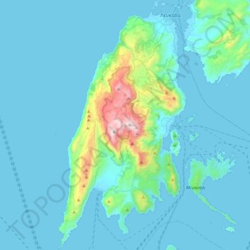
Nombre: Mapa topográfico Lefkada, altitud, relieve.
Altitud media: 111 m
Altitud mínima: -2 m
Altitud máxima: 1.160 m
Otros mapas topográficos
Haga clic en un mapa para ver su topografía, su altitud y su relieve.
Katomeri
Greece > Peloponnese, Western Greece and the Ionian > Lefkada Regional Unit
Katomeri, Meganisi Municipality, Lefkada Regional Unit, Ioanian Islands, Peloponnese, Western Greece and the Ionian, 310 83, Greece
Altitud media: 24 m
Meganisi
Greece > Peloponnese, Western Greece and the Ionian > Lefkada Regional Unit > Vathy
Meganisi, Vathy, Meganisi Municipality, Lefkada Regional Unit, Ioanian Islands, Peloponnese, Western Greece and the Ionian, 310 83, Greece
Altitud media: 41 m