
Haz una donación
Mapa topográfico Mount Mee
Haga clic en el mapa para ver la altitud.
Haz una donación
Acerca de este mapa
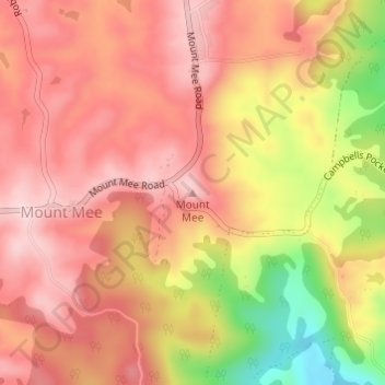
Nombre: Mapa topográfico Mount Mee, altitud, relieve.
Altitud media: 416 m
Altitud mínima: 247 m
Altitud máxima: 501 m
Haz una donación
Otros mapas topográficos
Haga clic en un mapa para ver su topografía, su altitud y su relieve.
City of Brisbane
Brisbane's topography is characterized by a series of hills and ranges that define its landscape. The city is situated on a low-lying floodplain, with the Brisbane River meandering through its heart, creating a winding course with many steep curves from the southwest to its mouth at Moreton Bay in the east.…
Altitud media: 71 m
Haz una donación
Bribie Island
Australia > Queensland > Brisbane
Bribie Island, located in Queensland, Australia, is a low-lying, elongated landmass stretching approximately 34 kilometers (21 miles) in length and up to 8 kilometers (5 miles) at its widest point. Composed predominantly of coastal sand plains, the island features two large, low-lying dunes extending…
Altitud media: 6 m
Haz una donación
Roma
Roma experiences a humid subtropical climate (Köppen: Cfa, Trewartha: Cfal); with hot summers with moderate rains; warm to hot, relatively dry springs and autumns; and mild, dry winters. Its location on the far south of the Carnarvon Range at an elevation of 299 metres above sea level means that it is cooler…
Altitud media: 315 m
Haz una donación
Haz una donación
Haz una donación
Haz una donación
Haz una donación
Haz una donación
Alexandra Hills
Scribbly Gums Conservation Area is located on the eastern edge of Alexandra Hills, bordered by Redland Hospital to the east, and Flinders St and Winchester Rd to the north. The conservation area occupies approximately 152 hectares and contains the Redlands Track Park - a collection of 30+ mountain bike trails…
Altitud media: 34 m
Sunshine Coast Regional
The Sunshine Coast Regional area in Queensland, Australia, features a diverse topography that ranges from coastal plains to rugged hinterlands. Along the coastline, the terrain is predominantly flat, with average elevations around 20 meters (66 feet) above sea level. Inland, the landscape transitions to…
Altitud media: 56 m
Haz una donación
Haz una donación
Haz una donación
Haz una donación
Haz una donación
Haz una donación
Haz una donación
Haz una donación
Haz una donación
Mornington Island
The general topography of the island, which lies on the eastern (Queensland) side of the Gulf of Carpentaria, is flat with the maximum elevation of 150 metres (490 ft). The island is fringed by mangrove forests and contains 10 estuaries, all in near pristine condition.
Altitud media: 3 m
Haz una donación
Haz una donación
Haz una donación
Brisbane River
Riverfire, which began in 1998, was a festival held in September each year at South Bank Parklands and surrounding areas (including the Victoria Bridge), to celebrate the Brisbane River. In 2009, the festival merged with Brisbane Festival. Riverfire, which was held at the end of the Brisbane Festival until…
Altitud media: 44 m
Haz una donación
Bentley Park
The land rises from an elevation of 9 metres (30 ft) aboe sea level in the east of the locality to 302 metres (991 ft) in the west of the locality.
Altitud media: 90 m
Haz una donación
Haz una donación
Haz una donación
Haz una donación