
Gracias por apoyar a este sitio ❤️
Haz una donación
Haz una donación
Mapa topográfico Hergatz
Haga clic en el mapa para ver la altitud.
Gracias por apoyar a este sitio ❤️
Haz una donación
Haz una donación
Acerca de este mapa
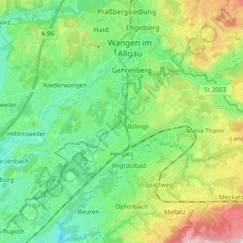
Nombre: Mapa topográfico Hergatz, altitud, relieve.
Lugar: Hergatz, Landkreis Lindau, Bavaria, Germany (47.63886 9.79342 47.67862 9.92441)
Altitud media: 616 m
Altitud mínima: 508 m
Altitud máxima: 813 m
Gracias por apoyar a este sitio ❤️
Haz una donación
Haz una donación
Otros mapas topográficos
Haga clic en un mapa para ver su topografía, su altitud y su relieve.