
Mapa topográfico Mont Blanc - Monte Bianco
Mapa interactivo
Haga clic en el mapa para ver la altitud.
Acerca de este mapa
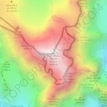
Nombre: Mapa topográfico Mont Blanc - Monte Bianco, altitud, relieve.
Altitud media: 4.092 m
Altitud mínima: 3.347 m
Altitud máxima: 4.804 m
The climate is cold and temperate (Köppen climate classification Cfb), and is greatly influenced by altitude. Being the highest part of the Alps, Mont Blanc and surrounding mountains can create their own weather patterns. Temperatures drop as the mountains gain in height, and the summit of Mont Blanc is a permanent ice cap, with temperatures around −20 °C (−4 °F). The summit is also prone to strong winds and sudden weather changes. Because of its great overall height, a considerable proportion is permanently glaciated or snow-covered and is exposed to extremely cold conditions.
Otros mapas topográficos
Haga clic en un mapa para ver su topografía, su altitud y su relieve.
Larzey
Italy > Aosta Valley > Courmayeur
Larzey, Courmayeur, Aosta Valley, 11013, Italy
Altitud media: 1.596 m
Val Veny
Italy > Aosta Valley > Courmayeur
Val Veny, Courmayeur, Aosta Valley, Italy
Altitud media: 2.151 m
Ghiacciaio del Miage
Italy > Aosta Valley > Courmayeur
Ghiacciaio del Miage, Sentiero 15 Rifugio Gonella, Courmayeur, Aosta Valley, Italy
Altitud media: 2.911 m