
Haz una donación
Mapa topográfico Beeston
Haga clic en el mapa para ver la altitud.
Haz una donación
Acerca de este mapa
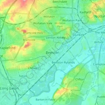
Nombre: Mapa topográfico Beeston, altitud, relieve.
Altitud media: 44 m
Altitud mínima: 20 m
Altitud máxima: 122 m
Haz una donación
Otros mapas topográficos
Haga clic en un mapa para ver su topografía, su altitud y su relieve.
Haz una donación
Haz una donación
River Erewash
United Kingdom > England > Nottinghamshire > Broxtowe
The approximate meaning of the name is not in doubt, but there is room for debate about the precise derivation and its connotations. Brewer gives the commonly accepted explanation that it comes from the Old English words irre ("wandering") and wisce ("wet meadow"). This is accepted by Kenneth Cameron, a…
Altitud media: 87 m
Haz una donación
Nottingham Canal Local Nature Reserve
United Kingdom > England > Nottinghamshire > Broxtowe
Altitud media: 66 m
Attenborough Nature Reserve
United Kingdom > England > Nottinghamshire > Broxtowe > Beeston
Altitud media: 34 m
Haz una donación