
Haz una donación
Mapa topográfico Schwöb
Haga clic en el mapa para ver la altitud.
Haz una donación
Acerca de este mapa
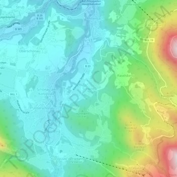
Nombre: Mapa topográfico Schwöb, altitud, relieve.
Altitud media: 770 m
Altitud mínima: 541 m
Altitud máxima: 1.495 m
Haz una donación
Otros mapas topográficos
Haga clic en un mapa para ver su topografía, su altitud y su relieve.
Haz una donación
Haz una donación
Untersberg
Germany > Bavaria > Landkreis Berchtesgadener Land
Several trails lead to the top, though most people prefer the Untersbergbahn cable car. Constructed over a period of over two years, and opening in April 1961, the eight and a half minute journey lifts passengers from the lower terminus at the village of Sankt Leonhard at 456 m (1,496 ft) over 1,320 m (4,330…
Altitud media: 797 m
Haz una donación
Watzmann
Germany > Bavaria > Landkreis Berchtesgadener Land > Ramsau bei Berchtesgaden
Altitud media: 1.177 m
Abtsdorfer See
Germany > Bavaria > Landkreis Berchtesgadener Land > Abtsdorf > Seethal
Altitud media: 441 m
Haz una donación