
Mapa topográfico Cow Lake
Mapa interactivo
Haga clic en el mapa para ver la altitud.
Acerca de este mapa
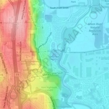
Nombre: Mapa topográfico Cow Lake, altitud, relieve.
Lugar: Cow Lake, Kent, King County, Washington, United States (47.39980 -122.27873 47.40102 -122.27642)
Altitud media: 51 m
Altitud mínima: 2 m
Altitud máxima: 149 m
Otros mapas topográficos
Haga clic en un mapa para ver su topografía, su altitud y su relieve.
East Hill
United States > Washington > King County > Kent > East Hill
East Hill, Kent, King County, Washington, 98030, United States
Altitud media: 108 m