
Mapa topográfico Byron
Mapa interactivo
Haga clic en el mapa para ver la altitud.
Byron
Byron is located in Byron Township at the junction of Illinois Route 72 and Illinois Route 2. Byron's topography includes a man-made prairie and the Rock River that passes through the town. It is generally flat and is ideal for farming in most regions. According to the 2010 census, Byron has a total area of 3.572 square miles (9.25 km2), of which 3.57 square miles (9.25 km2) (or 99.94%) is land and 0.002 square miles (0.01 km2) (or 0.06%) is water.
Acerca de este mapa
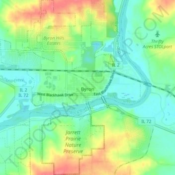
Nombre: Mapa topográfico Byron, altitud, relieve.
Altitud media: 226 m
Altitud mínima: 204 m
Altitud máxima: 267 m
Otros mapas topográficos
Haga clic en un mapa para ver su topografía, su altitud y su relieve.