
Gracias por apoyar a este sitio ❤️
Haz una donación
Haz una donación
Mapa topográfico Redwood Valley
Haga clic en el mapa para ver la altitud.
Gracias por apoyar a este sitio ❤️
Haz una donación
Haz una donación
Redwood Valley
Redwood Valley (formerly Basil) is a census-designated place (CDP) in Mendocino County, California, United States. It is located 9 miles (14 km) north of Ukiah, the county seat, at an elevation of 722 feet (220 m), and comprises the northern portion of the Ukiah Valley. It is about 15 miles (24 km) southeast of Willits. Potter Valley is to the east and Calpella to the south. The ZIP Code is 95470, and the community is in area code 707. The population of the CDP was 1,843 at the 2020 census.
Gracias por apoyar a este sitio ❤️
Haz una donación
Haz una donación
Acerca de este mapa
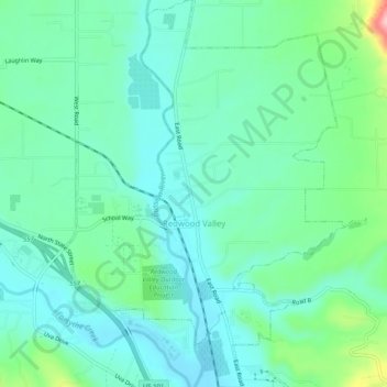
Nombre: Mapa topográfico Redwood Valley, altitud, relieve.
Altitud media: 246 m
Altitud mínima: 205 m
Altitud máxima: 383 m
Gracias por apoyar a este sitio ❤️
Haz una donación
Haz una donación
Otros mapas topográficos
Haga clic en un mapa para ver su topografía, su altitud y su relieve.