
Mapa topográfico Hills
Mapa interactivo
Haga clic en el mapa para ver la altitud.
Acerca de este mapa
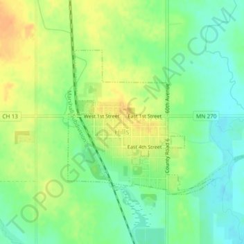
Nombre: Mapa topográfico Hills, altitud, relieve.
Altitud media: 445 m
Altitud mínima: 429 m
Altitud máxima: 463 m
According to the United States Census Bureau, the city has a total area of 0.54 square miles (1.40 km2); 0.53 square miles (1.37 km2) is land and 0.01 square miles (0.03 km2) is water. The landscape is flat with some gently rolling hills; however, the town's name does not derive from a particular topographical feature. The town includes two parks, Jacobson Park and the Rez. The Rez is a man made reservoir that is used for swimming, fishing and outdoor recreation. A gravel path circles the Rez (reservoir) and there are two small playgrounds. Multiple campsites and a cabin are also on the property as well as a disc golf course.
Otros mapas topográficos
Haga clic en un mapa para ver su topografía, su altitud y su relieve.
Hardwick
United States > Minnesota > Rock County
Hardwick, Rock County, Minnesota, 56134, United States
Altitud media: 490 m