
Mapa topográfico Llanmartin
Mapa interactivo
Haga clic en el mapa para ver la altitud.
Acerca de este mapa
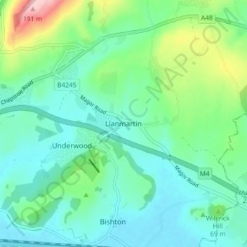
Nombre: Mapa topográfico Llanmartin, altitud, relieve.
Lugar: Llanmartin, Gwent, Wales, NP18 2EG, United Kingdom (51.58028 -2.89603 51.62028 -2.85603)
Altitud media: 48 m
Altitud mínima: 2 m
Altitud máxima: 196 m
Otros mapas topográficos
Haga clic en un mapa para ver su topografía, su altitud y su relieve.
Monmouthshire Canal Crumlin Branch
United Kingdom > Wales > Gwent > Newport
Monmouthshire Canal Crumlin Branch, Barrack Hill, Allt-Yr-Yn, Newport, Gwent, Wales, NP20 5EH, United Kingdom
Altitud media: 40 m
Monmouthshire Canal Crumlin Branch
United Kingdom > Wales > Gwent > Newport
Monmouthshire Canal Crumlin Branch, Ridgeway, Allt-Yr-Yn, Newport, Gwent, Wales, NP20 5DX, United Kingdom
Altitud media: 43 m
Parc Seymour
United Kingdom > Wales > Gwent > Newport
Parc Seymour, Penhow, Newport, Gwent, Wales, NP26 3AB, United Kingdom
Altitud media: 107 m
Underwood
United Kingdom > Wales > Gwent > Newport
Underwood, Newport, Gwent, Wales, NP18 2HQ, United Kingdom
Altitud media: 38 m
Bishton
United Kingdom > Wales > Gwent
Bishton, Gwent, Wales, NP18 2DZ, United Kingdom
Altitud media: 21 m
Malpas
United Kingdom > Wales > Gwent > Newport
Malpas, Newport, Gwent, Wales, United Kingdom
Altitud media: 30 m
Rhiwderin
United Kingdom > Wales > Gwent > Newport
Rhiwderin, Newport, Gwent, Wales, NP10 8RN, United Kingdom
Altitud media: 73 m