
Gracias por apoyar a este sitio ❤️
Haz una donación
Haz una donación
Mapa topográfico Hayling Island
Haga clic en el mapa para ver la altitud.
Gracias por apoyar a este sitio ❤️
Haz una donación
Haz una donación
Hayling Island
An Iron Age shrine in the north of Hayling Island was later developed into a Roman temple in the 1st century BC and was first recorded in Richard Scott's Topographical and Historical Account of Hayling Island (1826). The site was dug between 1897 and 1907 and again from 1976 to 1978. The remains are now buried under farmland. The first coin credited to Commius that was found in an archaeological dig was found at the temple. This Commius was probably the son of the Commius mentioned by Julius Caesar, although it is possible the coin was issued by the same Commius.
Gracias por apoyar a este sitio ❤️
Haz una donación
Haz una donación
Acerca de este mapa
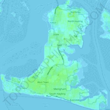
Nombre: Mapa topográfico Hayling Island, altitud, relieve.
Altitud media: 1 m
Altitud mínima: -4 m
Altitud máxima: 10 m
Gracias por apoyar a este sitio ❤️
Haz una donación
Haz una donación