
Gracias por apoyar a este sitio ❤️
Haz una donación
Haz una donación
Mapa topográfico Cortona
Haga clic en el mapa para ver la altitud.
Gracias por apoyar a este sitio ❤️
Haz una donación
Haz una donación
Cortona
The prevailing character of Cortona's architecture is medieval with steep narrow streets situated on a hillside at an elevation of 600 metres (2,000 ft) that embraces a view of the whole of the Valdichiana. From the Piazza Garibaldi (still referred to by the local population by its older name, Piazza Carbonaia) is a fine prospect of Lake Trasimeno, scene of Hannibal's ambush of the Roman army in 217 BC (Battle of Lake Trasimene).
Gracias por apoyar a este sitio ❤️
Haz una donación
Haz una donación
Acerca de este mapa
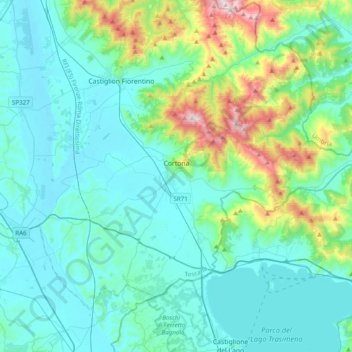
Nombre: Mapa topográfico Cortona, altitud, relieve.
Lugar: Cortona, Arezzo, Tuscany, Italy (43.15634 11.83351 43.37221 12.22465)
Altitud media: 375 m
Altitud mínima: 238 m
Altitud máxima: 1.063 m
Gracias por apoyar a este sitio ❤️
Haz una donación
Haz una donación
Otros mapas topográficos
Haga clic en un mapa para ver su topografía, su altitud y su relieve.
Gracias por apoyar a este sitio ❤️
Haz una donación
Haz una donación
Gracias por apoyar a este sitio ❤️
Haz una donación
Haz una donación
Gracias por apoyar a este sitio ❤️
Haz una donación
Haz una donación