
Gracias por apoyar a este sitio ❤️
Haz una donación
Haz una donación
Mapa topográfico Falkenberg
Haga clic en el mapa para ver la altitud.
Gracias por apoyar a este sitio ❤️
Haz una donación
Haz una donación
Acerca de este mapa
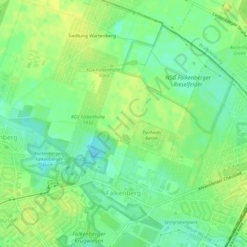
Nombre: Mapa topográfico Falkenberg, altitud, relieve.
Lugar: Falkenberg, Lichtenberg, Berlin, 13057, Germany (52.56610 13.53003 52.58764 13.56771)
Altitud media: 60 m
Altitud mínima: 49 m
Altitud máxima: 68 m
Gracias por apoyar a este sitio ❤️
Haz una donación
Haz una donación
Otros mapas topográficos
Haga clic en un mapa para ver su topografía, su altitud y su relieve.
Berlin
Berlin straddles the banks of the River Spree, which flows into the River Havel (a tributary of the River Elbe) in the western borough of Spandau. Among the city's main topographical features are the many lakes in the western and southeastern boroughs formed by the Spree, Havel, and Dahme rivers (the largest…
Altitud media: 47 m