
Gracias por apoyar a este sitio ❤️
Haz una donación
Haz una donación
Mapa topográfico Musreau Lake
Haga clic en el mapa para ver la altitud.
Gracias por apoyar a este sitio ❤️
Haz una donación
Haz una donación
Acerca de este mapa
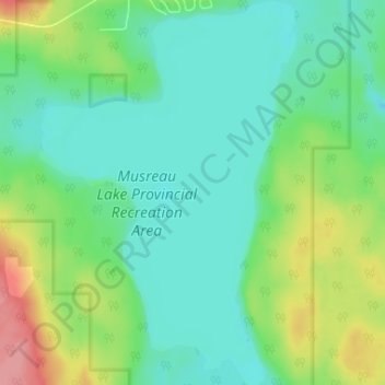
Nombre: Mapa topográfico Musreau Lake, altitud, relieve.
Altitud media: 889 m
Altitud mínima: 862 m
Altitud máxima: 956 m
Gracias por apoyar a este sitio ❤️
Haz una donación
Haz una donación
Otros mapas topográficos
Haga clic en un mapa para ver su topografía, su altitud y su relieve.
DeBolt
Canada > Alberta > Municipal District of Greenview
DeBolt is located in Peace Country, 58 km (36 mi) east from Grande Prairie and 54 km (34 mi) west of Valleyview along Highway 43. It lies in the Smoky River valley, at an elevation of 640 m (2,100 ft).
Altitud media: 644 m
Gracias por apoyar a este sitio ❤️
Haz una donación
Haz una donación