
Haz una donación
Mapa topográfico Suffolk
Haga clic en el mapa para ver la altitud.
Haz una donación
Suffolk
The west of the county lies on more resistant Cretaceous chalk. This chalk is responsible for a sweeping tract of largely downland landscapes that stretches from Dorset in the south west to Dover in the south east and north through East Anglia to the Yorkshire Wolds. The chalk is less easily eroded so forms the only significant hills in the county. The highest point in the county is Great Wood Hill, with an elevation of 128 metres (420 ft).
Haz una donación
Acerca de este mapa
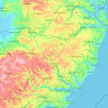
Nombre: Mapa topográfico Suffolk, altitud, relieve.
Lugar: Suffolk, England, United Kingdom (51.93176 0.33997 52.55022 1.76891)
Altitud media: 35 m
Altitud mínima: -4 m
Altitud máxima: 130 m
Haz una donación
Otros mapas topográficos
Haga clic en un mapa para ver su topografía, su altitud y su relieve.
Burton-on-Trent
United Kingdom > England > Staffordshire > East Staffordshire
Burton is about 109 miles (175 km) north west of London, about 30 miles north east of Birmingham, the UK's second largest city and about 23 miles east of the county town Stafford. It is at the easternmost border of the county of Staffordshire with Derbyshire, its suburbs and the course of the River Trent…
Altitud media: 69 m
Haz una donación
Haz una donación
Ipswich
United Kingdom > England > Suffolk > Ipswich > Ipswich
Ipswich experiences an oceanic climate, like the rest of the British Isles, with a narrow range of temperature and rainfall spread evenly throughout the year. One of the two nearest for which data is available is East Bergholt, about 7 miles (11 km) south west of the town centre and at a similar elevation, and…
Altitud media: 30 m
Haz una donación
Haz una donación
Romford
The town centre is about 50 feet (15 m) above sea level on a gravel terrace rising from the River Thames. The north of the town has developed on London Clay and is situated as much as 150 ft (46 m) above sea level. A continuous gentle rise in the eastern suburbs towards Gidea Park and Harold Wood peaks around…
Altitud media: 29 m
Haz una donación
Bebington
Bebington is on the eastern side of the Wirral Peninsula, approximately 10 km (6.2 mi) south-south-east of the Irish Sea at New Brighton, about 7.5 km (4.7 mi) east-north-east of the Dee Estuary at Gayton and less than 2 km (1.2 mi) west-north-west of the River Mersey at New Ferry. The area is situated at an…
Altitud media: 28 m
Haz una donación
Haz una donación
Sconce and Devon Park
United Kingdom > England > Nottinghamshire > Newark and Sherwood > Newark on Trent
Altitud media: 15 m
Haz una donación
Haz una donación
Lower Soudley
United Kingdom > England > Gloucestershire > Forest of Dean > Upper Soudley
Altitud media: 119 m
Haz una donación
Juniper Hill
United Kingdom > England > Oxfordshire > Cherwell District > Cottisford
Altitud media: 126 m
Haz una donación
Kitcher's Pond
United Kingdom > England > Hertfordshire > East Hertfordshire > Albury
Altitud media: 106 m
Haz una donación
Freefolk
United Kingdom > England > Hampshire > Basingstoke and Deane > Whitchurch
Altitud media: 101 m
Haz una donación
Haz una donación
Haz una donación
Haz una donación
Little Stanney Wood
United Kingdom > England > Cheshire West and Chester > Stoak > Little Stanney
Altitud media: 11 m
Haz una donación
Haz una donación
Haz una donación
Haz una donación
Haz una donación
Haz una donación
Haz una donación
Haz una donación
Basingstoke
United Kingdom > England > Hampshire > Basingstoke and Deane
Situated in a valley through the Hampshire Downs at an average elevation of 88 metres (289 ft) Basingstoke is a major interchange between Reading, Newbury, Andover, Winchester, and Alton, and lies on the natural trade route between the southwest of England and London. The area had been something of an…
Altitud media: 107 m
Haz una donación