
Haz una donación
Mapa topográfico Marienberg
Haga clic en el mapa para ver la altitud.
Haz una donación
Marienberg
The town is situated on a plateau north of the Ore Mountains ridge, at an elevation between 460 and 891 metres above sea level. It is approximately 31 kilometres south of Chemnitz, to which it is connected via the Flöha Valley Railway.
Haz una donación
Acerca de este mapa
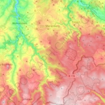
Nombre: Mapa topográfico Marienberg, altitud, relieve.
Lugar: Marienberg, Erzgebirgskreis, Saxony, 09496, Germany (50.50289 13.11699 50.69897 13.32772)
Altitud media: 657 m
Altitud mínima: 356 m
Altitud máxima: 901 m
Haz una donación
Otros mapas topográficos
Haga clic en un mapa para ver su topografía, su altitud y su relieve.
Markersbach
Germany > Saxony > Erzgebirgskreis
In 1889, Markersbach was connected to the railway line from Schwarzenberg to Annaberg, which was closed to passenger transport on 27 September 1997. The station lay in Mittweida’s municipal area and the platform signs read Mittweida-Markersbach. To overcome the great elevation differential, the railway's…
Altitud media: 600 m
Haz una donación