
Mapa topográfico Letchworth
Haga clic en el mapa para ver la altitud.
Acerca de este mapa
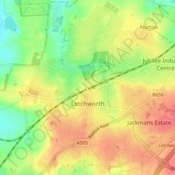
Nombre: Mapa topográfico Letchworth, altitud, relieve.
Lugar: Letchworth, Hertfordshire, England, United Kingdom (51.96105 -0.25510 51.99937 -0.19579)
Altitud media: 81 m
Altitud mínima: 48 m
Altitud máxima: 110 m
Otros mapas topográficos
Haga clic en un mapa para ver su topografía, su altitud y su relieve.
Bishop's Stortford
United Kingdom > England > Hertfordshire > East Hertfordshire > Thorley
Stortford, along with the rest of Britain, has a temperate maritime climate, with cool summers and mild winters. The nearest weather station for which averages and extremes are available is Stansted Airport, about 2+1⁄2 miles (4 kilometres) due east of Stortford's town centre. Located at an elevation of over…
Altitud media: 83 m
St Albans
United Kingdom > England > Hertfordshire
St Albans was an ancient borough created following the dissolution of the monastery in 1539. It consisted of the ancient parish of St Albans (also known as the Abbey parish) and parts of St Michael and St Peter. The municipal corporation was reformed by the Municipal Corporations Act 1835 and the boundary was…
Altitud media: 107 m
Spellbrook
United Kingdom > England > Hertfordshire > East Hertfordshire > Sawbridgeworth
Altitud media: 71 m
Letchworth
United Kingdom > England > Hertfordshire > North Hertfordshire > Letchworth
Altitud media: 80 m
Croxley Green
United Kingdom > England > Hertfordshire > Three Rivers > Rickmansworth
Altitud media: 67 m
Ashbrook
United Kingdom > England > Hertfordshire > North Hertfordshire > St Ippolyts
Altitud media: 85 m
Sawbridgeworth
United Kingdom > England > Hertfordshire > East Hertfordshire > Sawbridgeworth
Altitud media: 67 m
Berkhamsted
United Kingdom > England > Hertfordshire > Dacorum > Northchurch
The layout of Berkhamsted's centre is typical of a medieval market settlement: the linear High Street (aligned on the Akeman Street) forms the spine of the town (roughly aligned east–west), from which extend medieval burgage plots (to the north and south). The surviving burgage plot layout is the result of a…
Altitud media: 142 m
Waterford
United Kingdom > England > Hertfordshire > East Hertfordshire > Waterford
Altitud media: 66 m
St Albans
United Kingdom > England > Hertfordshire
The borough consisted of the ancient parish of St Albans (also known as the Abbey parish) and parts of the parishes of St Michael and St Peter. The borough was reformed by the Municipal Corporations Act 1835 to become a municipal borough, and the boundary was adjusted to additionally include part of the parish…
Altitud media: 103 m
Primrosehill
United Kingdom > England > Hertfordshire > Three Rivers > Abbots Langley
Altitud media: 111 m
Throcking
United Kingdom > England > Hertfordshire > East Hertfordshire > Buntingford
Altitud media: 126 m
Temple Dinsley
United Kingdom > England > Hertfordshire > North Hertfordshire > Preston
Altitud media: 124 m
Bendish
United Kingdom > England > Hertfordshire > North Hertfordshire > Breachwood Green
Altitud media: 128 m
Blackmore End
United Kingdom > England > Hertfordshire > St Albans > Wheathampstead
Altitud media: 114 m
Tewin Wood
United Kingdom > England > Hertfordshire > East Hertfordshire > Burnham Green
Altitud media: 101 m