
Gracias por apoyar a este sitio ❤️
Haz una donación
Haz una donación
Mapa topográfico Morgan Hill
Haga clic en el mapa para ver la altitud.
Gracias por apoyar a este sitio ❤️
Haz una donación
Haz una donación
Morgan Hill
Morgan Hill is approximately 24 mi (39 km) south of downtown San Jose, 13 mi (21 km) north of Gilroy, and 15 mi (24 km) inland from the Pacific coast. Lying in a roughly 4-mile-wide (6 km) southern extension of the Santa Clara Valley, it is bounded by the Santa Cruz Mountains to the west and the Diablo Range to the east. At the valley floor, Morgan Hill lies at an elevation of about 350 feet (107 m) above MSL.
Gracias por apoyar a este sitio ❤️
Haz una donación
Haz una donación
Acerca de este mapa
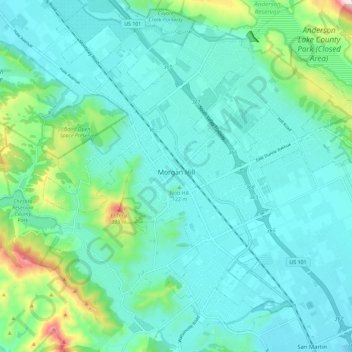
Nombre: Mapa topográfico Morgan Hill, altitud, relieve.
Altitud media: 153 m
Altitud mínima: 78 m
Altitud máxima: 502 m
Gracias por apoyar a este sitio ❤️
Haz una donación
Haz una donación
Otros mapas topográficos
Haga clic en un mapa para ver su topografía, su altitud y su relieve.
Sierra Vista Open Space Preserve
United States > California > Santa Clara County > San Jose
Altitud media: 484 m