
Mapa topográfico Paskenta
Haga clic en el mapa para ver la altitud.
Paskenta
Paskenta (Wintun: Paskenti) is a small unincorporated town in Tehama County, California. Historically, it had greater local importance due to the presence of an active lumber mill. The ZIP Code is 96074. The community is inside area code 530 and the Paskenta CDP. Paskenta sits at an elevation of 725 feet (221 m). The 2010 United States census reported Paskenta's population was 112. Paskenta was originally inhabited by a tribe of Nomlaki people who are now part of the federally-recognized Paskenta Band of Nomlaki Indians.
Acerca de este mapa
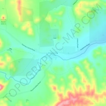
Nombre: Mapa topográfico Paskenta, altitud, relieve.
Lugar: Paskenta, Tehama County, California, 96074, United States (39.86429 -122.56697 39.90429 -122.52697)
Altitud media: 268 m
Altitud mínima: 213 m
Altitud máxima: 389 m
Otros mapas topográficos
Haga clic en un mapa para ver su topografía, su altitud y su relieve.