
Mapa topográfico Hawker
Mapa interactivo
Haga clic en el mapa para ver la altitud.
Acerca de este mapa
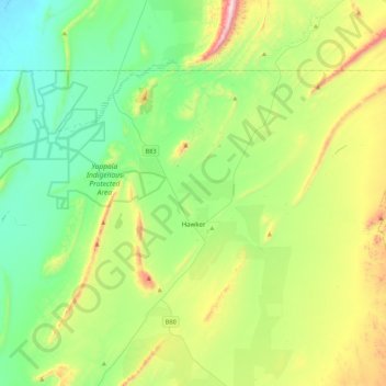
Nombre: Mapa topográfico Hawker, altitud, relieve.
Altitud media: 346 m
Altitud mínima: 95 m
Altitud máxima: 971 m
Otros mapas topográficos
Haga clic en un mapa para ver su topografía, su altitud y su relieve.
Quorn
Australia > South Australia > The Flinders Ranges Council
Quorn, The Flinders Ranges Council, South Australia, 5433, Australia
Altitud media: 311 m
Hawker
Australia > South Australia > The Flinders Ranges Council > Hawker
Hawker, The Flinders Ranges Council, South Australia, 5434, Australia
Altitud media: 329 m
Quorn
Australia > South Australia > The Flinders Ranges Council > Quorn
Quorn, The Flinders Ranges Council, South Australia, 5433, Australia
Altitud media: 316 m