
Mapa topográfico Washington, D.C.
Mapa interactivo
Haga clic en el mapa para ver la altitud.
Acerca de este mapa
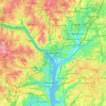
Nombre: Mapa topográfico Washington, D.C., altitud, relieve.
Altitud media: 63 m
Altitud mínima: -2 m
Altitud máxima: 161 m
The highest natural elevation in the District is 409 feet (125 m) above sea level at Fort Reno Park in upper northwest Washington. The lowest point is sea level at the Potomac River. The geographic center of Washington is near the intersection of 4th and L Streets NW.