
Gracias por apoyar a este sitio ❤️
Haz una donación
Haz una donación
Mapa topográfico Bear Lake
Haga clic en el mapa para ver la altitud.
Gracias por apoyar a este sitio ❤️
Haz una donación
Haz una donación
Bear Lake
Formed in a half graben valley straddling the Idaho-Utah border, the lake has an approximate area of 109 square miles (280 km2) and sits at an elevation of 5,924 feet (1,806 m) along the northeast side of the Wasatch Range and the east side of the Bear River Mountains.
Gracias por apoyar a este sitio ❤️
Haz una donación
Haz una donación
Acerca de este mapa
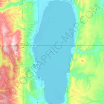
Nombre: Mapa topográfico Bear Lake, altitud, relieve.
Lugar: Bear Lake, Garden City, Rich County, Utah, United States (41.84591 -111.41042 42.12034 -111.25602)
Altitud media: 2.038 m
Altitud mínima: 1.801 m
Altitud máxima: 2.817 m
Gracias por apoyar a este sitio ❤️
Haz una donación
Haz una donación