
Haz una donación
Mapa topográfico Altenglan
Haga clic en el mapa para ver la altitud.
Haz una donación
Altenglan
The municipality lies in the uplands in the Western Palatinate on the river Glan, which is the village's namesake, at an elevation in the valley of some 200 m above sea level, although the elevations within municipal limits reach almost 400 m (Bistersberg 387 m on the Glan's left bank; Kalmet 390 m on the Glan's right bank), and on the slopes of the Potzberg within the formerly self-administering municipality of Mühlbach almost 500 m. Altenglan lies roughly 5 km northeast of the district seat and nearest town, Kusel, and 25 km northwest of Kaiserslautern. In Altenglan, the Kuselbach and the Reichenbach empty into the Glan. The dale here forms a broad bowl, although the pattern is broken somewhat by the two streams that meet the Glan here, one from each side. Part of the Potzberg massif lies within Altenglan as does part of the long Remigiusberg ridge, although these hills' summits all lie outside the municipality's boundaries. The municipality has an area of 1 362 ha, of which 237 ha is wooded.
Haz una donación
Acerca de este mapa
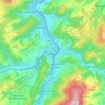
Nombre: Mapa topográfico Altenglan, altitud, relieve.
Altitud media: 305 m
Altitud mínima: 191 m
Altitud máxima: 561 m
Haz una donación
Otros mapas topográficos
Haga clic en un mapa para ver su topografía, su altitud y su relieve.
Schönenberg
Germany > Rhineland-Palatinate > Landkreis Kusel > Schönenberg-Kübelberg
Altitud media: 266 m