
Gracias por apoyar a este sitio ❤️
Haz una donación
Haz una donación
Mapa topográfico Angerstein
Haga clic en el mapa para ver la altitud.
Gracias por apoyar a este sitio ❤️
Haz una donación
Haz una donación
Acerca de este mapa
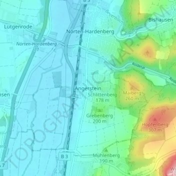
Nombre: Mapa topográfico Angerstein, altitud, relieve.
Altitud media: 168 m
Altitud mínima: 126 m
Altitud máxima: 371 m
Gracias por apoyar a este sitio ❤️
Haz una donación
Haz una donación
Otros mapas topográficos
Haga clic en un mapa para ver su topografía, su altitud y su relieve.
Einbeck
Germany > Lower Saxony > Landkreis Northeim
In the Early Middle Ages a number of villages existed along the river Ilme in the middle Leine valley before Einbeck was founded. On January 1, 1158 Einbeck was first mentioned in a deed of Friedrich Barbarossa, which mentioned … in loco qui Einbike vocatur …. and related to a transfer of an estate in the…
Altitud media: 198 m
Gracias por apoyar a este sitio ❤️
Haz una donación
Haz una donación