
Gracias por apoyar a este sitio ❤️
Haz una donación
Haz una donación
Mapa topográfico Roads End
Haga clic en el mapa para ver la altitud.
Gracias por apoyar a este sitio ❤️
Haz una donación
Haz una donación
Acerca de este mapa
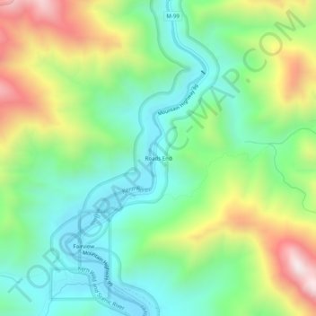
Nombre: Mapa topográfico Roads End, altitud, relieve.
Lugar: Roads End, Tulare County, California, United States (35.91499 -118.50440 35.95499 -118.46440)
Altitud media: 1.366 m
Altitud mínima: 1.064 m
Altitud máxima: 1.944 m
Gracias por apoyar a este sitio ❤️
Haz una donación
Haz una donación
Otros mapas topográficos
Haga clic en un mapa para ver su topografía, su altitud y su relieve.
Sequoia National Park
United States > California > Tulare County
Many park visitors enter Sequoia National Park through its southern entrance near the town of Three Rivers at Ash Mountain at 1,700 ft (520 m) elevation. The lower elevations around Ash Mountain contain the only National Park Service-protected California Foothills ecosystem, consisting of blue oak woodlands,…
Altitud media: 2.515 m