
Haz una donación
Mapa topográfico Old Crow
Haga clic en el mapa para ver la altitud.
Haz una donación
Acerca de este mapa
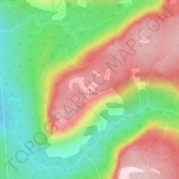
Nombre: Mapa topográfico Old Crow, altitud, relieve.
Lugar: Old Crow, Newfoundland, Newfoundland and Labrador, Canada (49.57282 -57.78966 49.57292 -57.78956)
Altitud media: 417 m
Altitud mínima: 165 m
Altitud máxima: 693 m
Haz una donación
Otros mapas topográficos
Haga clic en un mapa para ver su topografía, su altitud y su relieve.
Haz una donación
Bell Island
Canada > Newfoundland and Labrador > Wabana
The coast is very rocky and consists almost entirely of steep cliffs tens of meters high that tower up to 45 kilometres (28 mi) above sea level. The island, which continues to gain in altitude especially close to the coastline, reaches a maximum height of 148 metres (486 ft). Because the central part of the…
Altitud media: 30 m
Haz una donación
Terra Nova National Park
Canada > Newfoundland and Labrador
Terra Nova's landscape is typical of the northeast coast of Newfoundland, but with remnants of the Appalachian Mountains contributing to widely varied and rugged topography throughout the region. The park's seacoast consists of several rocky "fingers" jutting into Bonavista Bay along an area stretching from…
Altitud media: 58 m
Haz una donación
Haz una donación
Haz una donación
Haz una donación
Haz una donación
Haz una donación
Haz una donación
Haz una donación
Haz una donación
Haz una donación
Haz una donación
Haz una donación
Haz una donación
Clarenville
Canada > Newfoundland and Labrador
The Clarenville area has many of the physical features characteristic of the East Coast of Newfoundland and has a marine climate. It lies along the coastal slopes which rise from the Atlantic Ocean towards the interior central plateau of the island. The dominating physical feature is a ridge of broken peaks…
Altitud media: 102 m
Haz una donación
Haz una donación
Haz una donación
Haz una donación
Haz una donación
Haz una donación
Haz una donación
Haz una donación
Haz una donación
Haz una donación