
Haz una donación
Mapa topográfico Indio
Haga clic en el mapa para ver la altitud.
Haz una donación
Indio
According to the United States Census Bureau, the city has a total area of 75.6 square kilometers (29 sq mi), 99.97% of which is land and 0.03% is water. The official elevation of Indio is below sea level; the city hall is 14 feet (4 m) below sea level, as the eastern half of the Coachella Valley drops as low as 150 feet (50 m) below sea level (the lakeshore of the Salton Sea is 15 miles (24 km) south of Indio). About 3 miles (5 km) north and east of Indio is the San Andreas Fault, a major tectonic plate boundary of the Pacific and North American plates.
Haz una donación
Acerca de este mapa
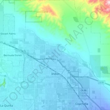
Nombre: Mapa topográfico Indio, altitud, relieve.
Lugar: Indio, Riverside County, California, United States (33.67102 -116.30128 33.81654 -116.16418)
Altitud media: 74 m
Altitud mínima: -30 m
Altitud máxima: 784 m
Haz una donación
Otros mapas topográficos
Haga clic en un mapa para ver su topografía, su altitud y su relieve.