
Haz una donación
Mapa topográfico Öhringen
Haga clic en el mapa para ver la altitud.
Haz una donación
Öhringen
Öhringen is located in the western, deeper part of the Hohenlohe plain, between the Keuper stage of the Swabian-Franconian Forest and the Kocher valley. The town spreads out over the flat valley of the Ohrn, a small river, which flows about 10 kilometres (6 mi) down the valley in the district Ohrnberg into the Kocher river. The town is situated between elevation 168 metres (551 ft), in the Kocher at the county border at Möglingen, and 486 m (1,594 ft), already above the forest on the Charles Mainhardt Furter plane, which belongs to the district Michelbach. The height of the town itself varies between 215–280 metres (705–919 ft).
Haz una donación
Acerca de este mapa
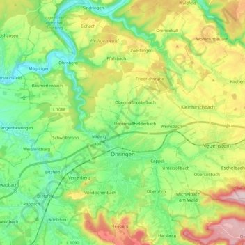
Nombre: Mapa topográfico Öhringen, altitud, relieve.
Altitud media: 282 m
Altitud mínima: 168 m
Altitud máxima: 487 m
Haz una donación
Otros mapas topográficos
Haga clic en un mapa para ver su topografía, su altitud y su relieve.