
Mapa topográfico Zouk Mosbeh
Mapa interactivo
Haga clic en el mapa para ver la altitud.
Zouk Mosbeh
Zouk Mosbeh (Arabic: زوق مصبح) is a town and municipality in the Keserwan District of the Mount Lebanon Governorate in Lebanon. It is located 12 kilometers north of Beirut. Zouk Mosbeh's average elevation is 170 meters above sea level and its total land area is 453 hectares. Its inhabitants are predominantly Maronite Catholics and Christians from other denominations. There are three schools in the town, one public and two private, which together enrolled a total of 4,633 students in 2005–2006. There were 167 businesses with over five employees operating in Zouk Mosbeh as of 2006.
Acerca de este mapa
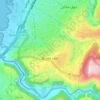
Nombre: Mapa topográfico Zouk Mosbeh, altitud, relieve.
Altitud media: 114 m
Altitud mínima: 0 m
Altitud máxima: 334 m
Otros mapas topográficos
Haga clic en un mapa para ver su topografía, su altitud y su relieve.
Faraya
Lebanon > Keserwan-Jbeil Governorate
Faraya (Arabic: فاريا) is a village and municipality in the Keserwan District of the Keserwan-Jbeil Governorate, Lebanon. It is located 46 kilometers north of Beirut. Elevation start from 1290 meters to 2000 meters above sea level and its total land area is 870 hectares. Faraya's inhabitants are…
Altitud media: 1.558 m
Ehmej
Lebanon > Keserwan-Jbeil Governorate
Ehmej has a total land area of 1,742 hectares. The town's average elevation is 1,140 meters above sea level. Neighboring municipalities include Mish Mish to the west, Jaj to the north, Laqlouq and Mazraat es-Siyad to the east and Almat el-Shemaliat and Almat al-Janubiat to the south.
Altitud media: 1.203 m
Lehfed
Lebanon > Keserwan-Jbeil Governorate
Lehfed (Arabic: لحفد, also known as Lihfid) is a municipality in the Byblos District of Keserwan-Jbeil Governorate, Lebanon. It is 55 kilometers north of Beirut. Lehfed has an average elevation of 1000 meters above sea level and a total land area of 542 hectares. There were three companies with more than…
Altitud media: 1.049 m
Aaqoura
Lebanon > Keserwan-Jbeil Governorate
Aqoura (Arabic: عاقورة, also spelled Aaqoura, "Akoura") is a mountainous village in the Byblos District of Keserwan-Jbeil Governorate, Lebanon. It is lovated 68 kilometers north of Beirut. Aaqoura has an average elevation of 1,600 meters above sea level (between 1000 and 2189 m) and a total land area of…
Altitud media: 1.590 m
Faraya
Lebanon > Keserwan-Jbeil Governorate
Faraya (Arabic: فاريا) is a village and municipality in the Keserwan District of the Keserwan-Jbeil Governorate, Lebanon. It is located 46 kilometers north of Beirut. Elevation start from 1290 meters to 2000 meters above sea level and its total land area is 870 hectares. Faraya's inhabitants are…
Altitud media: 1.558 m
Sehaile
Lebanon > Keserwan-Jbeil Governorate
Sehaileh (Arabic: سهيلة; also spelled Seheileh or Shayleh) is a municipality in the Keserwan District of the Mount Lebanon Governorate in Lebanon. It is located 25 kilometers north of Beirut. Its average elevation is 550 meters above sea level and its total land area is 221 hectares. Sehaileh's…
Altitud media: 475 m
Kfardebian
Lebanon > Keserwan-Jbeil Governorate
Kfardebian (Arabic: كفر دبيان; also spelled Kfar Dibiane and also known as Moucha'a Keserwan) is a municipality in the Keserwan District of the Keserwan-Jbeil Governorate in Lebanon. It is located 45 kilometers north of Beirut. Its average elevation is 1,220 meters above sea level and its total land…
Altitud media: 1.758 m
Laqlouq
Lebanon > Keserwan-Jbeil Governorate
Laqlouq (Arabic: لقلوق), also spelled Laklouk and also known as ′Arab Laqlouq (Arabic: عرب القلوق) is a small mountainous village in mountainous area in the Byblos District of Keserwan-Jbeil Governorate, Lebanon. It is located 69 kilometers northeast of Beirut. Laqlouq has an average elevation…
Altitud media: 1.746 m