
Haz una donación
Mapa topográfico Bosco
Haga clic en el mapa para ver la altitud.
Haz una donación
Acerca de este mapa
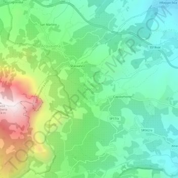
Nombre: Mapa topográfico Bosco, altitud, relieve.
Lugar: Bosco, San Giovanni a Piro, Salerno, Campania, Italy (40.05289 15.43712 40.09289 15.47712)
Altitud media: 388 m
Altitud mínima: 22 m
Altitud máxima: 1.217 m
Haz una donación
Otros mapas topográficos
Haga clic en un mapa para ver su topografía, su altitud y su relieve.
Positano
Positano’s physical geography is defined by its steep, cliffside setting along the Amalfi Coast, where pastel-colored buildings appear to cascade down toward the Tyrrhenian Sea. The town is built on rugged limestone slopes of the Lattari Mountains, creating a “vertical village” layout with narrow…
Altitud media: 244 m
Haz una donación
Positano
Positano’s physical geography is defined by its steep, cliffside setting along the Amalfi Coast, where pastel-colored buildings appear to cascade down toward the Tyrrhenian Sea. The town is built on rugged limestone slopes of the Lattari Mountains, creating a "vertical village" layout with narrow stairways…
Altitud media: 244 m
Haz una donación
Haz una donación
Positano
Positano’s physical geography is defined by its steep, cliffside setting along the Amalfi Coast, where pastel-colored buildings appear to cascade down toward the Tyrrhenian Sea. The town is built on rugged limestone slopes of the Lattari Mountains, creating a “vertical village” layout with narrow…
Altitud media: 244 m
Haz una donación
Haz una donación
Haz una donación
Haz una donación