
Mapa topográfico Orsay
Mapa interactivo
Haga clic en el mapa para ver la altitud.
Acerca de este mapa
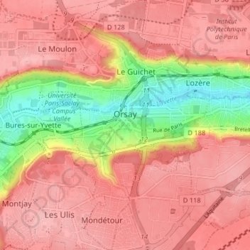
Nombre: Mapa topográfico Orsay, altitud, relieve.
Altitud media: 131 m
Altitud mínima: 53 m
Altitud máxima: 168 m
Otros mapas topográficos
Haga clic en un mapa para ver su topografía, su altitud y su relieve.
Paris Basin
France > Ile-de-France > Essonne > Bièvres
The landscape is one of very broad valleys (flood plains), modest watershed hills and well-drained plateaux of comparatively little altitude. In the south-east and east the plain of Champagne and the Seuil de Bourgogne (Threshold of Burgundy) differential erosion of the strata has left low scarps with the dip…
Altitud media: 126 m