
Haz una donación
Mapa topográfico Saint-Jean-de-Maurienne
Haga clic en el mapa para ver la altitud.
Haz una donación
Saint-Jean-de-Maurienne
Saint-Jean-de-Maurienne is on the route of the future Lyon-Turin rail link. Homes, businesses, the current railway station and the rescue centre are affected by the project. The Lyon Turin Railway company (LTF) which manages the construction projects plans to build new railway station in the Sous-le-Bourg neighborhood, serving both the historic line and the new Lyon-Turin line. Geological and topographical investigations are underway. The project promises to be even more complex than that of the Channel Tunnel.
Haz una donación
Acerca de este mapa
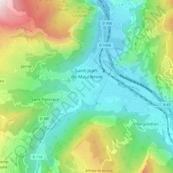
Nombre: Mapa topográfico Saint-Jean-de-Maurienne, altitud, relieve.
Altitud media: 946 m
Altitud mínima: 504 m
Altitud máxima: 2.020 m
Haz una donación
Otros mapas topográficos
Haga clic en un mapa para ver su topografía, su altitud y su relieve.
Mollard Durand
France > Auvergne-Rhône-Alpes > Savoy > Saint-Martin-de-la-Porte
Altitud media: 1.050 m
Les Ménuires
France > Auvergne-Rhône-Alpes > Savoy
The resort was founded in 1964 and has an altitude range of 1,850 m (6,070 ft).
Altitud media: 2.063 m
Haz una donación
Le Charvet
France > Auvergne-Rhône-Alpes > Savoy > Bourg-Saint-Maurice > Arc 1800
Altitud media: 1.651 m
Haz una donación
La Ville des Glaciers
France > Auvergne-Rhône-Alpes > Savoy > Bourg-Saint-Maurice
Altitud media: 2.180 m
Haz una donación
Le Désert d'Entremont
France > Auvergne-Rhône-Alpes > Savoy > Entremont-le-Vieux
Altitud media: 1.161 m
Haz una donación
Haz una donación
Haz una donación
Haz una donación
Le Laisonnay d'En Bas
France > Auvergne-Rhône-Alpes > Savoy > Champagny-en-Vanoise
Altitud media: 2.140 m
Haz una donación