
Haz una donación
Mapa topográfico Ofena
Haga clic en el mapa para ver la altitud.
Haz una donación
Acerca de este mapa
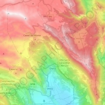
Nombre: Mapa topográfico Ofena, altitud, relieve.
Lugar: Ofena, L'Aquila, 67025, Italy (42.28454 13.72000 42.40552 13.81373)
Altitud media: 1.149 m
Altitud mínima: 340 m
Altitud máxima: 1.909 m
Haz una donación
Otros mapas topográficos
Haga clic en un mapa para ver su topografía, su altitud y su relieve.
Apennine Mountains
A separate branch, the Apuan Alps, goes southwest, bordering the coast south of La Spezia. Whether they are to be considered part of the Apennines is a matter of opinion; certainly, they are part of the Apennine System. Topographically only the valley of the River Serchio, which running parallel to the coast…
Altitud media: 1.735 m
Haz una donación
Rocca Calascio
At an elevation of around 1,460 metres (4,790 ft), the castle is the highest fortress in the Apennines. Built of stone and masonry exclusively for military purposes and intended only to accommodate troops and never as a residence for nobles, the fortress overlooks the Plain of Navelli at one of the highest…
Altitud media: 1.171 m
Haz una donación
Apennine Mountains
A separate branch, the Apuan Alps, goes southwest, bordering the coast south of La Spezia. Whether they are to be considered part of the Apennines is a matter of opinion; certainly, they are part of the Apennine System. Topographically only the valley of the River Serchio, which running parallel to the coast…
Altitud media: 1.735 m
Rocca Calascio
At an elevation of 1,512 metres (4,961 ft), the castle is the highest fortress in the Apennines. Built of stone and masonry exclusively for military purposes and intended only to accommodate troops and never as residence for nobles, the fortress overlooks the Plain of Navelli at one of the highest points in…
Altitud media: 1.171 m