
Mapa topográfico Karlskrona
Mapa interactivo
Haga clic en el mapa para ver la altitud.
Acerca de este mapa
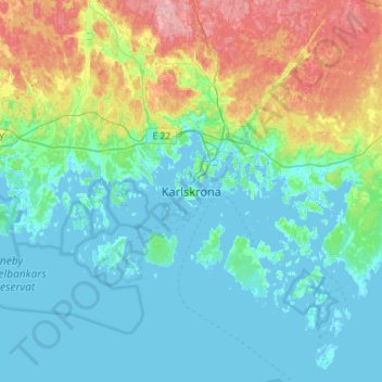
Nombre: Mapa topográfico Karlskrona, altitud, relieve.
Lugar: Karlskrona, Karlskrona kommun, Blekinge County, 371 31, Sweden (56.00211 15.42664 56.32211 15.74664)
Altitud media: 25 m
Altitud mínima: -3 m
Altitud máxima: 113 m
When the city was founded in 1680, it was primarily thought of as a military city, with many defenses and fortifications exploiting the particular topography of the city. Some fortifications were located on the main island (Trossö) such as the Bastion Aurora, built at the beginning of the 18th century, but much of it was located on the nearby islands (Ljungskär, Mjölnareholmen, Godnatt, Koholmen and Kurrholmen) or more distant, such as the islands closing the bay, with in particular the important fortress of Kungsholmen and its circular port.
Otros mapas topográficos
Haga clic en un mapa para ver su topografía, su altitud y su relieve.
Sölvesborg
Sölvesborg, Sölvesborgs kommun, Blekinge County, 294 31, Sweden
Altitud media: 13 m
Hällevik
Hällevik, Sölvesborgs kommun, Blekinge County, 294 71, Sweden
Altitud media: 11 m
Sandviken
Sandviken, Sölvesborgs kommun, Blekinge County, 294 40, Sweden
Altitud media: 6 m
Vilshult
Vilshult, Olofströms kommun, Blekinge County, 293 95, Sweden
Altitud media: 113 m
Sölvesborgs kommun
Sölvesborgs kommun, Blekinge County, Sweden
Altitud media: 9 m
Skärvgöl
Skärvgöl, Ronneby kommun, Blekinge County, 370 11, Sweden
Altitud media: 88 m
Fröjdadal
Fröjdadal, Ronneby kommun, Blekinge County, Sweden
Altitud media: 67 m
Karlshamn
Sweden > Blekinge County > Karlshamn
Karlshamn, Karlshamns kommun, Blekinge County, 37436, Sweden
Altitud media: 14 m
Torp
Sweden > Blekinge County > Karlskrona > Torp
Torp, Karlskrona, Karlskrona kommun, Blekinge County, Sweden
Altitud media: 3 m