
Mapa topográfico Sankt Wendel
Mapa interactivo
Haga clic en el mapa para ver la altitud.
Sankt Wendel
St. Wendel is situated on the river Blies west of the Bosenberg hill at an elevation of 938 feet (286 m). Its highest elevation is the Bosenberg hill at 1591 feet (485 m); the lowest is where the river Blies exits St. Wendel heading for Ottweiler at 853 feet (260 m).
Acerca de este mapa
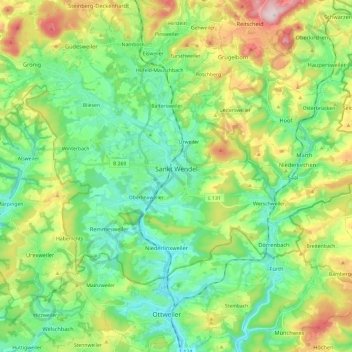
Nombre: Mapa topográfico Sankt Wendel, altitud, relieve.
Lugar: Sankt Wendel, Landkreis St. Wendel, Saarland, 66606, Germany (49.41609 7.06774 49.51141 7.30564)
Altitud media: 359 m
Altitud mínima: 252 m
Altitud máxima: 589 m
Otros mapas topográficos
Haga clic en un mapa para ver su topografía, su altitud y su relieve.