
Haz una donación
Mapa topográfico Freital
Haga clic en el mapa para ver la altitud.
Haz una donación
Acerca de este mapa
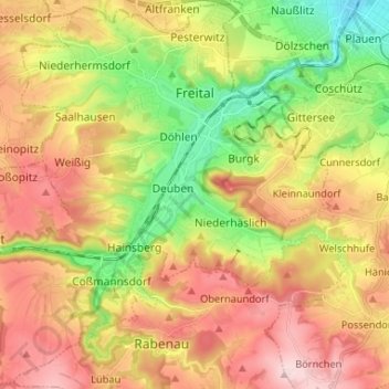
Nombre: Mapa topográfico Freital, altitud, relieve.
Altitud media: 275 m
Altitud mínima: 127 m
Altitud máxima: 425 m
Haz una donación
Otros mapas topográficos
Haga clic en un mapa para ver su topografía, su altitud y su relieve.
Saxon Switzerland
Germany > Saxony > Sächsische Schweiz-Osterzgebirge
Saxon Switzerland forms the northern part of the Elbe Sandstone Mountains range, located on the German-Czech border. To the east, it transitions into the Lusatian Highlands and, to the west, into the Ore Mountains. The Czech part of the Elbe Sandstone Mountains is partly formed by the Bohemian Switzerland…
Altitud media: 341 m
Haz una donación
Haz una donación
Topograph
Germany > Saxony > Sächsische Schweiz-Osterzgebirge > Rosenthal-Bielatal
Altitud media: 385 m
Diebskeller
Germany > Saxony > Sächsische Schweiz-Osterzgebirge > Königstein > Pfaffendorf > Hütten
Altitud media: 248 m
Siamesische Zwillinge, Dick
Germany > Saxony > Sächsische Schweiz-Osterzgebirge > Bad Schandau
Altitud media: 366 m
Haz una donación