
Haz una donación
Mapa topográfico Saxon Switzerland
Haga clic en el mapa para ver la altitud.
Haz una donación
Saxon Switzerland
Saxon Switzerland forms the northern part of the Elbe Sandstone Mountains range, located on the German-Czech border. To the east, it transitions into the Lusatian Highlands and, to the west, into the Ore Mountains. The Czech part of the Elbe Sandstone Mountains is partly formed by the Bohemian Switzerland national park. The highest elevation in Saxon Switzerland is the Großer Zschirnstein at 562 m above sea level.
Haz una donación
Acerca de este mapa
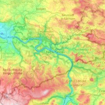
Nombre: Mapa topográfico Saxon Switzerland, altitud, relieve.
Altitud media: 341 m
Altitud mínima: 110 m
Altitud máxima: 719 m
Haz una donación
Otros mapas topográficos
Haga clic en un mapa para ver su topografía, su altitud y su relieve.
Saxon Switzerland National Park
Germany > Saxony > Sächsische Schweiz-Osterzgebirge
Altitud media: 356 m
Haz una donación
Sebnitz
Germany > Saxony > Sächsische Schweiz-Osterzgebirge
The town of Sebnitz lies in the valley of the river Sebnitz and its side valleys between 251 and 460 m above sea level between the mountains of Saxon Switzerland and the Lusatian Highlands. Topographically the town itself lies in the West Lusatian Upland, but lies right on the border with the Upper Lusatian…
Altitud media: 342 m
Haz una donación
Haz una donación
Haz una donación
Haz una donación
Topograph
Germany > Saxony > Sächsische Schweiz-Osterzgebirge > Rosenthal-Bielatal
Altitud media: 385 m
Diebskeller
Germany > Saxony > Sächsische Schweiz-Osterzgebirge > Königstein > Pfaffendorf > Hütten
Altitud media: 248 m
Haz una donación
Siamesische Zwillinge, Dick
Germany > Saxony > Sächsische Schweiz-Osterzgebirge > Bad Schandau
Altitud media: 366 m