
Mapa topográfico Meghalaya
Mapa interactivo
Haga clic en el mapa para ver la altitud.
Acerca de este mapa
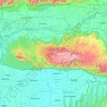
Nombre: Mapa topográfico Meghalaya, altitud, relieve.
Lugar: Meghalaya, India (25.03065 89.81444 26.11817 92.80274)
Altitud media: 244 m
Altitud mínima: 0 m
Altitud máxima: 2.336 m
Meghalaya, alongside neighbouring Indian states, has been of archaeological interest. People have lived in Meghalaya since the Neolithic period. Neolithic sites discovered so far are located in areas of high elevation in Khasi Hills, Garo Hills and in neighbouring states, where Neolithic style jhum or shifting cultivation is practiced even today. The highland plateaus fed by abundant rains provided safety from floods and a rich soil. The importance of Meghalaya is its possible role in human history via domestication of rice. One of the competing theories for the origin of rice comes from Ian Glover, who states, "India is the center of greatest diversity of domesticated rice with over 20,000 identified species and Northeast India is the most favorable single area of the origin of domesticated rice." The limited archaeology done in the hills of Meghalaya suggest human settlement since ancient times.
Otros mapas topográficos
Haga clic en un mapa para ver su topografía, su altitud y su relieve.
Bengaluru
India > Karnataka > Bangalore North
Bengaluru, Bangalore North, Bengaluru Urban District, Karnataka, India
Altitud media: 881 m
3d
India > Rajasthan > Ganganagar Tehsil > 1 LNP
3d, 1 LNP, Ganganagar Tehsil, Sri Ganganagar District, Rajasthan, India
Altitud media: 178 m
Patna
India > Bihar > Patna Rural
Patna, Patna Rural, Patna District, Bihar, 800001, India
Altitud media: 51 m
Mysuru
India > Karnataka > Mysuru taluk
Mysuru, Mysuru taluk, Mysuru District, Karnataka, 570001, India
Altitud media: 727 m
Vellinezhi
India > Kerala > Ottappalam
Vellinezhi, Ottappalam, Palakkad District, Kerala, 679504, India
Altitud media: 57 m
Shrivardhan Fort
India > Maharashtra > Mawal > Udhewadi > Vanati Kakurwardi
Shrivardhan Fort, Rajmachi Trail, Vanati Kakurwardi, Udhewadi, Mawal, Pune District, Maharashtra, 410400, India
Altitud media: 533 m
Jiribam
India > Manipur > Jiribam tehsill
Jiribam, Jiribam tehsill, Jiribam District, Manipur, 788104, India
Altitud media: 40 m
Pune
India > Maharashtra > Pune City > Pune
Pune, Pune City, Pune District, Maharashtra, 411001, India
Altitud media: 641 m
Umapur
India > Maharashtra > Georai
Umapur, Georai, Beed District, Maharashtra, India
Altitud media: 464 m
Kriti
India > Jammu and Kashmir > Kokernag Tehsil
Kriti, Kokernag Tehsil, Anantnag District, Jammu and Kashmir, India
Altitud media: 2.288 m
Indhira Nagar
India > Tamil Nadu > Perambalur
Indhira Nagar, Perambalur, Perambalur District, Tamil Nadu, 621220, India
Altitud media: 129 m
Indore
India > Madhya Pradesh > Juni Indore Tahsil
Indore, Juni Indore Tahsil, Indore District, Madhya Pradesh, 452001, India
Altitud media: 555 m
Bachupally mandal
Bachupally mandal, Medchal–Malkajgiri District, Telangana, 500090, India
Altitud media: 593 m
Umapur
India > Maharashtra > Jalgaon Jamod
Umapur, Jalgaon Jamod, Buldhana District, Maharashtra, India
Altitud media: 440 m
Bharathinagara
India > Karnataka > Madduru taluk
Bharathinagara, Madduru taluk, Mandya District, Karnataka, 571422, India
Altitud media: 633 m
Wardha
India > Maharashtra > Wardha
Wardha, Wardha District, Maharashtra, 442001, India
Altitud media: 266 m
shrinagar
India > Uttarakhand > Almora
shrinagar, Almora, Almora District, Uttarakhand, 263652, India
Altitud media: 1.646 m
Anaimalai
India > Tamil Nadu > Pollachi
Anaimalai, Pollachi, Coimbatore District, Tamil Nadu, 642104, India
Altitud media: 262 m
North Sentinel Island
India > Andaman and Nicobar Islands > Ferrargunj
North Sentinel Island, Ferrargunj, South Andaman District, Andaman and Nicobar Islands, India
Altitud media: 20 m
Old Valparai
India > Tamil Nadu > Valparai
Old Valparai, Valparai, Coimbatore District, Tamil Nadu, 642127, India
Altitud media: 1.043 m
Yellanalli
India > Tamil Nadu > Coonoor
Yellanalli, Coonoor, Nilgiris District, Tamil Nadu, 643243, India
Altitud media: 2.100 m
Coimbatore
India > Tamil Nadu > Coimbatore North
Coimbatore, Coimbatore North, Coimbatore District, Tamil Nadu, 641001, India
Altitud media: 452 m