
Mapa topográfico St. Helier
Mapa interactivo
Haga clic en el mapa para ver la altitud.
Acerca de este mapa
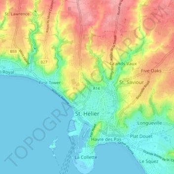
Nombre: Mapa topográfico St. Helier, altitud, relieve.
Lugar: St. Helier, Jersey (49.16785 -2.13694 49.21889 -2.08495)
Altitud media: 37 m
Altitud mínima: -2 m
Altitud máxima: 101 m
The topography of the parish is one of the most varied. The marshland on which the town is situated is encircled by highlands which protect the town from the worst winds. In the southeast of the parish, rising from the plains in the centre of town is Mont de Ville and Mount Bingham which divide the Havre des Pas district from the Harbour.
Otros mapas topográficos
Haga clic en un mapa para ver su topografía, su altitud y su relieve.
La Hougue des Geonnais (dolmen)
La Hougue des Geonnais (dolmen), Rue des Geonnais, Saint Ouen, JE3 2DL, Jersey
Altitud media: 45 m