
Haz una donación
Mapa topográfico Prunedale
Haga clic en el mapa para ver la altitud.
Haz una donación
Prunedale
Prunedale is a census-designated place in Monterey County, California, United States. It is located 8 miles (13 km) north of Salinas at an elevation of 92 feet (28 m). The population was 18,885 as of the 2020 census, up from 17,560 in 2010. Plum trees were grown in Prunedale in the early days of its founding, but the trees died soon after due to poor irrigation and fertilizer.
Haz una donación
Acerca de este mapa
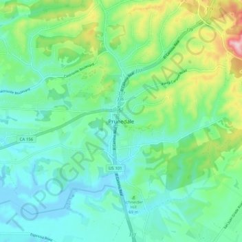
Nombre: Mapa topográfico Prunedale, altitud, relieve.
Altitud media: 69 m
Altitud mínima: -8 m
Altitud máxima: 275 m
Haz una donación
Otros mapas topográficos
Haga clic en un mapa para ver su topografía, su altitud y su relieve.
Monterey
United States > California > Monterey County
During winter, snow occasionally falls in the higher elevations of the Santa Lucia Mountains and Gabilan Mountains that overlook Monterey, but snow in Monterey itself is extremely rare. A few unusual events in January 1962, February 1976, and December 1997 brought a light coating of snow to Monterey. In March…
Altitud media: 50 m